Successful 3D Subsurface Mapping of Seafloor Massive Sulfides (Ishizu et al., 2022, Geophysics)
Ishizu, K. Siripunvaraporn, W., Goto, T. N., Koike, K., Kasaya, T., & Iwamoto, H. (2022). A cost-effective three-dimensional marine controlled-source electromagnetic survey: exploring seafloor massive sulfides. Geophysics, 87(4), E219–E241.
Point 1: Successful 3D subsurface mapping of seafloor massive sulfides
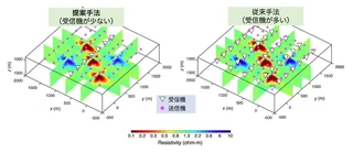
Point 2 (Most Important): Proposal of a new 3D marine electromagnetic exploration technology that reduces receivers and costs while maintaining performance equivalent to conventional methods
Marine electromagnetic exploration is effective for estimating the 3D subsurface distribution of seafloor massive sulfides. However, existing methods require a large number of receivers to obtain 3D information, leading to high survey costs. In this paper, we proposed a new 3D marine electromagnetic technology that reduces the number of receivers and survey costs while maintaining performance equivalent to conventional methods. The proposed method is very simple, involving the placement of a single line of receivers in the center of the survey track. We first demonstrated the effectiveness of this method using a synthetic model and data. We then applied the proposed method to explore the Ieyama hydrothermal field in the Okinawa Trough and estimated the 3D subsurface distribution of seafloor massive sulfides, successfully identifying areas likely to be deposit bodies.
